


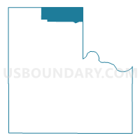
Voting District 302, Logan County, Oklahoma
About
Outline

Summary
| Unique Area Identifier | 654327 |
| Name | Voting District 302 |
| County | Logan County |
| State | Oklahoma |
| Area (square miles) | 33.00 |
| Land Area (square miles) | 32.96 |
| Water Area (square miles) | 0.04 |
| % of Land Area | 99.88 |
| % of Water Area | 0.12 |
| Latitude of the Internal Point | 36.13028260 |
| Longtitude of the Internal Point | -97.43730850 |
Maps

Graphs
Select a template below for downloading or customizing gragh for Voting District 302, Logan County, Oklahoma


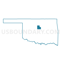
Neighbors
Neighoring Voting District (by Name) Neighboring Voting District on the Map
- Voting District 106, Garfield County, OK
- Voting District 301, Logan County, OK
- Voting District 302, Noble County, OK
- Voting District 303, Noble County, OK
- Voting District 304, Logan County, OK
- Voting District 401, Payne County, OK
Top 10 Neighboring County Subdivision (by Population) Neighboring County Subdivision on the Map
- Stillwater CCD, Payne County, OK (63,113)
- Perry CCD, Noble County, OK (7,753)
- South Garfield CCD, Garfield County, OK (3,851)
- North Logan CCD, Logan County, OK (1,235)
Top 10 Neighboring Place (by Population) Neighboring Place on the Map
Top 10 Neighboring Unified School District (by Population) Neighboring Unified School District on the Map
Top 10 Neighboring State Legislative District Lower Chamber (by Population) Neighboring State Legislative District Lower Chamber on the Map
- State House District 31, OK (44,222)
- State House District 33, OK (37,766)
- State House District 35, OK (36,242)
- State House District 38, OK (32,291)
Top 10 Neighboring State Legislative District Upper Chamber (by Population) Neighboring State Legislative District Upper Chamber on the Map
- State Senate District 21, OK (81,344)
- State Senate District 19, OK (77,948)
- State Senate District 20, OK (68,510)
Top 10 Neighboring 111th Congressional District (by Population) Neighboring 111th Congressional District on the Map
Top 10 Neighboring Census Tract (by Population) Neighboring Census Tract on the Map
- Census Tract 110, Payne County, OK (5,735)
- Census Tract 6007, Logan County, OK (4,662)
- Census Tract 12, Garfield County, OK (3,851)
- Census Tract 9571, Noble County, OK (2,860)